By Marvin J. Lopez, Director of Client Success, PointMan Prostar
Abstract
The underground infrastructure industry is undergoing a structural shift driven by advancements in mobile computing, cloud platforms, and real-time positioning technologies. Traditional utility mapping workflows have relied on fragmented systems across field data collection, geospatial platforms, and engineering environments, which introduce delays, inconsistencies, and operational risk. Emerging technologies are enabling a more integrated data lifecycle where real-time data capture, RTK-enabled positioning, and cloud-based synchronization reduce reliance on post-processing and allow utility data to function as a persistent, verifiable system of record. Early adoption is producing measurable improvements in safety, efficiency, and project delivery across various sectors, contributing to standardized, interoperable data environments that support long-term infrastructure management and digital twin initiatives. This paper outlines the limitations of legacy workflows, the structure of modern integrated systems, and the implications as utility data becomes a foundational layer of connected infrastructure.
Supporting Presentation
Utility Mapping Workflow Transformation-2026PointManPresentation2026
Introduction: The Subsurface Data Challenge
Buried utilities support essential services like electric, water, gas, and telecommunications, yet records of these assets are often incomplete, outdated, or distributed across multiple stakeholders. This lack of reliable subsurface data introduces risk across all phases of infrastructure development. According to the 2023 CGA DIRT Report, inaccurate markings and incomplete data continue to impact project timelines and increase the likelihood of utility damage, leading to higher costs and safety concerns. Often, the challenge is not an absence of data, but the inability to access, verify, and apply it effectively in the field due to legacy workflows that rely on disconnected systems and manual processes. Reliable subsurface data is now required for safe and efficient project execution.
Limitations of Traditional Workflows
Traditional utility mapping workflows are structured around multiple disconnected processes:
- Field crews collect data using standalone devices or manual methods.
- Data is transferred to office teams for processing and interpretation.
- Engineers convert data into CAD or GIS formats for design and planning.
This model introduces several inefficiencies:
- Delayed data availability: Information is not immediately accessible to decision-makers.
- Inconsistent data formats: Data translation between systems increases error likelihood.
- Specialized skill requirements: Processing often requires highly trained personnel.
- Limited data reuse: Information is frequently recreated rather than maintained as a persistent record.
These limitations lead to repeated site visits, extended timelines, and increased risk exposure.
Modern Utility Data Workflows
Advancements in positioning, mobile computing, and cloud technology enable a new approach where data is:
- Captured in the field with high positional accuracy.
- Synchronized in real time across teams.
- Accessed through cloud-based platforms.
- Exported directly into engineering and GIS environments.
Key characteristics include:
- Field-to-cloud synchronization: Data is immediately available across the organization.
- Standardized data structures: Organized consistently to support interoperability.
- Improved accessibility: Multiple stakeholders can access data without specialized tools.
- Reduced post-processing: Data is validated during collection.
Consequently, utility data becomes more reliable and useful throughout the project lifecycle.
Technology Convergence
Modern workflows are enabled by the convergence of several advancements:
- RTK-enabled GNSS positioning.
- Electromagnetic and ground-penetrating radar systems.
- Mobile GIS applications.
- Cloud-based data platforms.
- Integration with CAD and enterprise GIS systems.
These allow field teams to capture high-quality data for immediate operational decision-making, where utility data becomes part of a continuous lifecycle supporting planning, design, and long-term asset management.
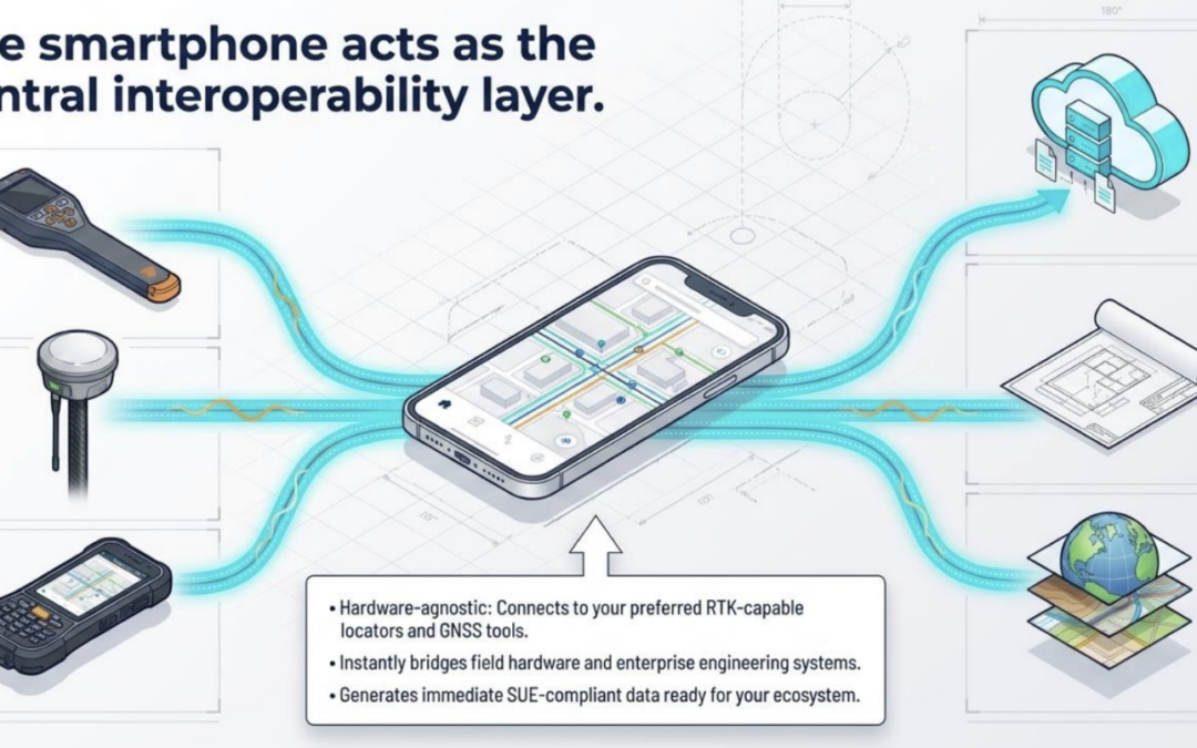
The Strategic Implication for Hardware Ecosystems
The role of hardware manufacturers is changing as the industry shifts from hardware-defined to data-defined workflows. Historically, value was tied to proprietary, closed systems that limited data transfer and reuse. Emerging technologies now expect data to persist across a project’s full lifecycle.
Implications include:
- Interoperability requirement: Solutions must integrate into broader workflows.
- Data continuity priority: Emphasis is on maintaining consistent, reusable data.
- Software redundancy friction: Separate software layers for each hardware platform increase complexity.
- Ecosystem alignment: Providers aligning with integrated workflows can expand their market reach.
Measured Impact of Modern Workflows
Early adopters report measurable outcomes:
- Reduced utility strike incidents.
- Faster permitting and project approvals.
- Improved coordination between field and office teams.
- Lower project costs due to reduced rework.
These improvements drive the industry from reactive problem-solving toward proactive planning.
Broader Industry Impact
The evolution of utility data workflows benefits multiple segments:
- Engineering and SUE firms: Improved accuracy and reduced processing time.
- Construction teams: Better visibility into subsurface conditions.
- Utility owners: Improved asset management and reduced damage.
- Public agencies: Enhanced infrastructure planning and regulatory compliance.
Industry-Specific Data Workflows and Opportunities
While the shift is consistent, impact varies by sector:
Utility Locating and Damage Prevention (811 Ecosystem)
- Characteristics: High-frequency activity, 811 ticketing systems, time-sensitive.
- Challenges: Temporary markings are not digitally preserved; data is rarely standardized.
- Opportunity: Digital capture at the point of marking creates persistent infrastructure records, reducing redundant requests and improving accuracy.
Construction and SUE (Subsurface Utility Engineering)
- Characteristics: High reliance on verified data; tight timelines.
- Challenges: Incomplete records and limited data reuse across phases.
- Opportunity: Capture data once and reuse it throughout the project lifecycle to improve safety and delivery.
Utilities
- Characteristics: Large distributed networks; long asset lifecycles.
- Challenges: Fragmented records across legacy systems; inconsistent data quality.
- Opportunity: Maintain a continuous, up-to-date record for improved asset management and coordination.
Oil and Gas
- Characteristics: High safety/environmental risk; strict regulatory compliance.
- Challenges: High cost of errors; difficulty maintaining data across large geographic areas.
- Opportunity: Greater accuracy and real-time visibility support compliance and reduce operational risk.
Municipalities and DOTs
- Characteristics: Oversight of public right-of-way; multi-stakeholder coordination.
- Challenges: Lack of unified system of record; difficulty enforcing standards.
- Opportunity: Standardized, cloud-based workflows allow agencies to maintain control while enabling stakeholder access.
Cross-Industry Implication
Across all sectors, the industry is moving toward a model where data is:
- Captured once.
- Verified in the field.
- Maintained as a continuous record.
- Shared across stakeholders in real time.
Conclusion: From Tools to Infrastructure
Infrastructure transformation requires reliable subsurface data. Modern workflows allow this data to be a continuous record across project lifecycles, evolving from a simple project deliverable into a foundational layer of infrastructure intelligence.