
From Pixels to Precision: Multi-Sensor Inspection and a Decade of Asset Management at North Texas Municipal Water District By Amin Tehrani, Ph.D., P.E. and Scott Hoelzle, P.E.- Wastewater Conveyance Group.
In January 2026, the pipeline Condition Assessment Program (CAP) at North Texas Municipal Water District (NTMWD) was named Asset Management Project of the Year at the Underground Infrastructure Conference. The recognition marks the near-completion of a ten-year commitment the District made in 2016, when NTMWD began a program to inspect all 147 miles of its large-diameter gravity mains, as part of its obligations under the Texas Commission on Environmental Quality’s (TCEQ) Sanitary Sewer Overflow Initiative. A foundational decision made at the outset of the program has shaped nearly every finding and recommendation produced since: rather than relying on closed-circuit television (CCTV) alone, as has historically been standard practice across much of the industry, NTMWD structured the program around multi-sensor inspection (MSI).
This article presents a practitioner-level discussion of that decision, nine years on. It addresses the specific limitations of CCTV as a stand-alone assessment tool, the condition data that sonar makes available and CCTV cannot, the framework used to translate that data into repair, rehabilitation, or replacement decisions, and the operational requirements of sustaining a program of this scale over a decade. It also addresses a limitation identified within the current MSI platform itself, and the equipment change planned for the program’s second ten-year cycle.
Limitations of CCTV as a Stand-Alone Assessment Tool
CCTV inspection has long been the industry standard for gravity pipeline condition assessment, and for good reasons. A qualified operator can reliably identify cracks, root intrusion, joint separation, and blockages, and the resulting footage is straightforward for reviewers and stakeholders outside the inspection discipline to interpret.
However, CCTV is fundamentally a visual, qualitative assessment method. It documents the appearance of a defect but does not quantify its magnitude, its rate of progression, or conditions below the flow line. A CCTV inspection cannot measure remaining wall thickness in a concrete pipe or quantify ovality in a plastic pipe to any meaningful precision. More significantly, CCTV cannot assess conditions obscured by flow: sediment accumulation, debris loading, or deformation occurring at or below the waterline is effectively unobservable by camera, regardless of image quality.
For a program intended to establish a defensible, decade-long baseline condition dataset to support capital planning, this qualitative limitation was not acceptable. The program required quantified, repeatable measurements rather than descriptive observations.
Multi-Sensor Inspection Technology
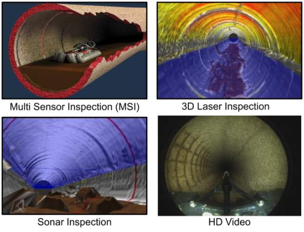
NTMWD’s inspections are performed using the RedZone Robotics HDProfiler platform, which integrates three sensing technologies in a single inspection pass: laser profiling, high-definition CCTV, and sonar.
Laser profiling scans the unsubmerged pipe wall and measures the inspected wall location against the original as-built geometry, to a stated margin of 0.1 percent. In concrete pipe, this differential quantifies wall loss due to corrosion in measurable units, rather than a qualitative descriptor such as “moderate corrosion observed.” In plastic pipe, the same geometric data is used to quantify ovality, which is correlated to estimated remaining useful life (RUL) using deflection thresholds developed in consultation with manufacturer guidance. HD CCTV is recorded concurrently and provides visual correlation to the laser and sonar data, allowing observed defects to be tied to a specific quantified location along the pipe.
Sonar addresses the portion of the pipe that CCTV cannot reach: the submerged pipe surface, including the invert. Sonar measures depth of flow and quantifies the height and volume of debris accumulated on the invert, and it can detect deformation in the submerged pipe wall to a stated margin of 0.4 percent. This capability — quantifying submerged debris volume and deformation — represents the most significant practical advantage MSI provides over CCTV-only inspection, and is discussed in greater detail below.
A Known Limitation of the Current CCTV Component
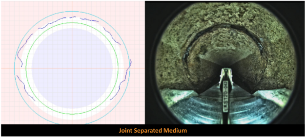
It is worth noting, in the interest of a complete and technically accurate account, that the CCTV component of the platform used throughout the program’s first ten-year cycle employs a fixed fisheye lens. This configuration provides a wide field of view but does not allow the operator to redirect or zoom the camera to a specific point of interest during review. As a result, minor surface defects — hairline cracks in particular — are, on occasion, more difficult to positively identify than they would be with a steerable camera. This limitation is inherent to the fixed fisheye configuration rather than to the laser or sonar components of the platform, and it does not affect the quantitative wall-loss, ovality, or debris-volume measurements described above.
Having identified this limitation through nine years of field experience, NTMWD is planning to procure an upgraded MSI platform for its second ten-year inspection cycle that incorporates a 360-degree camera system. A 360-degree camera allows the operator to pan and reorient the field of view after the inspection pass has been recorded, rather than being limited to the single fixed perspective captured in the field. This is expected to materially improve the detection rate of minor structural defects, including hairline cracking, that are more easily missed under the current fixed fisheye configuration.
The Value of Quantified Submerged Data
The practical significance of sonar-derived debris volume and submerged deformation data is best understood in the context of a typical field scenario. A gravity segment may appear entirely sound above the flow line — intact concrete, no visible cracking, an unremarkable CCTV record — while carrying a substantial sediment load on the invert. CCTV alone provides no means of distinguishing a thin sediment film from a significant accumulation; sonar provides an actual measured volume.
This distinction directly changes the recommended course of action. Where a segment exhibits surcharging or reduced hydraulic capacity and sonar indicates a high sediment volume, the appropriate response is a cleaning contract followed by re-inspection, not a capital rehabilitation project. Under a CCTV-only assessment, the same segment could reasonably be flagged as a capacity or structural concern and advanced toward a rehabilitation recommendation it did not require. Conversely, sonar can identify invert deformation or a bellied section concealed beneath accumulated debris that a camera would not detect at all, since the debris itself obstructs the view. This represents a genuine structural finding that a CCTV-only inspection would miss entirely, and one that, left unaddressed, is more likely to progress to an emergency failure than to be captured as a planned point repair.
Under a CCTV-only protocol, a segment that cannot be fully observed below the flow line is typically documented as “unable to assess below flow line,” and is then either assigned a conservative condition score it may not warrant, or advanced without further evaluation. Neither outcome is desirable: an unwarranted conservative score can direct capital toward a segment that requires only cleaning, while advancing an unassessed segment risks allowing a genuine structural defect to progress undetected. Sonar resolves this by converting “unable to assess” into a quantified value — a debris volume, a flow depth, a deformation measurement — that is incorporated into the same scoring framework applied to every other segment in the system. Across nearly 600,000 linear feet of inspected pipe, the cumulative value of this capability lies not in any single finding but in the program’s consistent ability to distinguish an operations and maintenance issue from a capital one, and a genuine structural defect from a debris accumulation that would otherwise be indistinguishable from one another.
From Data to Decision: The Scoring Framework
Every inspected pipe segment is assigned a condition score from 1 to 5, based on estimated RUL. For concrete pipe, a deterioration rate per year is calculated from observed wall loss and pipe age, then extrapolated to a projected failure point, defined as less than 0.75 inches of remaining wall thickness based on the District’s field experience. For plastic pipe, the score is derived from measured ovality against thresholds developed with manufacturer input. Additional structural defects — fractures, holes, or cracks — can escalate a segment’s score independent of the calculated deterioration rate, since such defects indicate the pipeline has already failed structurally.
Segments inspected using sonar only — typically re-inspections performed following a cleaning recommendation — are not assigned an RUL score, since the pipe wall has not been directly observed in those instances. This distinction is a deliberate feature of the program’s methodology: condition scores are assigned only where the underlying sensor data directly supports them.
Condition scores feed a risk-based prioritization model. NTMWD developed a hydraulic and asset model of its conveyance system using Innovyze InfoAsset Planner, scoring each asset on likelihood of failure (LOF) and consequence of failure (COF), each on a scale of 1 to 10, and multiplying the two to produce a total risk score out of 100. LOF incorporates the RUL score where available, along with material, age, maintenance history, and surcharge status. COF is assessed largely independent of condition, based on accessibility, depth, traffic impact, environmental sensitivity, inflow and infiltration exposure, and redundancy. Criticality changes infrequently for a given asset, while condition changes continuously, which is the basis for repeating the inspection cycle at regular intervals.
Program Results
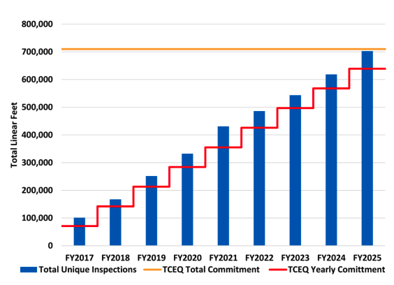
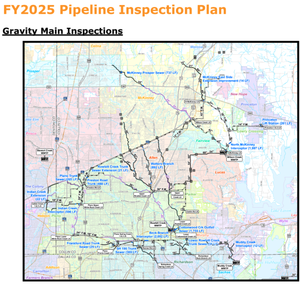
Through FY2025 approximately 702,607 linear feet of gravity pipeline — roughly 98 percent of the District’s gravity system — and 1638 manholes had been inspected under the program. Approximately 5 percent of inspected footage, or roughly 36,420 linear feet, received critical RUL scores of 4 or 5 and was advanced directly to repair action. Of the manholes inspected, approximately 62 percent received a rehabilitation recommendation, the majority related to coating failure or frame-and-cover integrity, both of which represent direct sources of inflow and infiltration. Under the risk-based assessment, over 93 percent of gravity mains scored Low or Very Low risk, with approximately 1 percent scoring High or Very High. These results indicate a system that is, in aggregate, in sound condition, while providing a quantified and defensible basis for identifying and prioritizing the small proportion of assets that require near-term intervention.
Operational Requirements
The technical capability of the MSI platform is only part of the program’s success; sustaining it operationally over a decade presents its own requirements. Each inspection window requires coordination of flow control or temporary bypass pumping with District operations staff, scheduling of access with external inspection crews, and management of traffic control and confined-space entry procedures, particularly at manholes located within active roadways. Scheduling is routinely subject to revision based on weather, flow conditions, and contractor availability.
Manhole inspections follow a comparable logistical process only at a smaller scale. Manholes are inspected using a 3D optical scanner lowered into and drawn back up through the structure in a single pass, generating a point cloud that an operator can subsequently review to measure defects, corrosion, and frame or cover condition without requiring a repeat site visit.
Data management represents a further significant operational requirement. Each inspection generates laser, CCTV, and sonar data that must be processed, scored, and loaded into the District’s asset management system, ITpipes, in a format consistent with Pipeline Assessment Certification Program (PACP) and Manhole Assessment Certification Program (MACP) standards, so that it remains usable to reviewers who were not present for the original inspection. NTMWD also engages an independent third-party vendor to perform quality assurance and quality control review of inspection data prior to its use as the basis for repair recommendations; this independent review has identified discrepancies that would otherwise have gone unaddressed and is considered a necessary component of a program of this scale.
Internal communication and cross-departmental coordination represent the most significant lesson learned over the program’s first nine years. A program of this scope requires sustained engagement across operations, engineering, information technology, and finance, in addition to continuous coordination with subconsultants to maintain schedule and scope alignment. The information technology component in particular warrants specific attention: the data volumes and the number of distinct software platforms involved are readily underestimated, and the District continues to work toward making inspection data accessible across user groups rather than remaining siloed within the system that originally captured it.
Looking Ahead
As the first ten-year CAP cycle concludes, NTMWD is initiating a second cycle. The District’s full pipeline inventory will be reassessed at a minimum of 10 percent of the system annually, maintaining a current condition picture. As noted above, the second cycle will also incorporate an upgraded MSI platform featuring a 360-degree camera system, addressing the minor-defect detection limitation identified with the current fixed fisheye CCTV configuration.
The recognition received this year marks the completion of the program’s first cycle. The observed outcome of nine years of multi-sensor inspection data is a quantified, defensible understanding of where risk actually resides within the system, including conditions below the flow line, ovality, and wall loss that a camera alone could never quantify. Those capabilities are the practical foundation of the District’s asset management program going forward.
Amin Darabnoush Tehrani, PhD, PE, is a recipient of the ISTT Academy Award and ASCE UESI’s Younger Member Award and specializes in pipeline engineering. He is a member of multiple AWWA and ASCE committees and is actively involved in advancing the practice of pipeline engineering and infrastructure management. He currently serves as the Wastewater Conveyance Program Manager at the North Texas Municipal Water District.
Scott Hoelzle has served the water and wastewater sector for over 25 years as both a consulting engineer and an operations manager for a public utility. He is currently employed by the North Texas Municipal Water District where he serves as the Manager of the Wastewater Conveyance System. The System provides service to approximately 1.6 Million people located north and east of Dallas and includes 25 lift stations, over 245 miles of large diameter pipelines, odor control facilities, and remote meter stations.
Thanks,
Amin Tehrani, PhD, PE, PACP
Wastewater Conveyance Program Manager
North Texas Municipal Water District